


Long, long ago in the Val d'Hérens
Following the collapse of the mountain range, the Variscan terrains drifted north to eventually collide with the then Europe. The Paleotethys Ocean opens, only to be subducted later under the enlarged Europe creating a new mountain range on its southern border, comprising the Alps and Mediterranean area. This mountain range collapsed in turn, creating a series of Carboniferous and Permian rifts. During the Triassic this rifting phase ceased, finally allowing the return of the sea into the Alpine region.
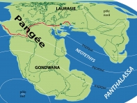
The Variscan Orogenic Event produced the Pangaean super-continent 320 Ma ago; its fracturing in the early Jurassic produced the Alpine Ocean.
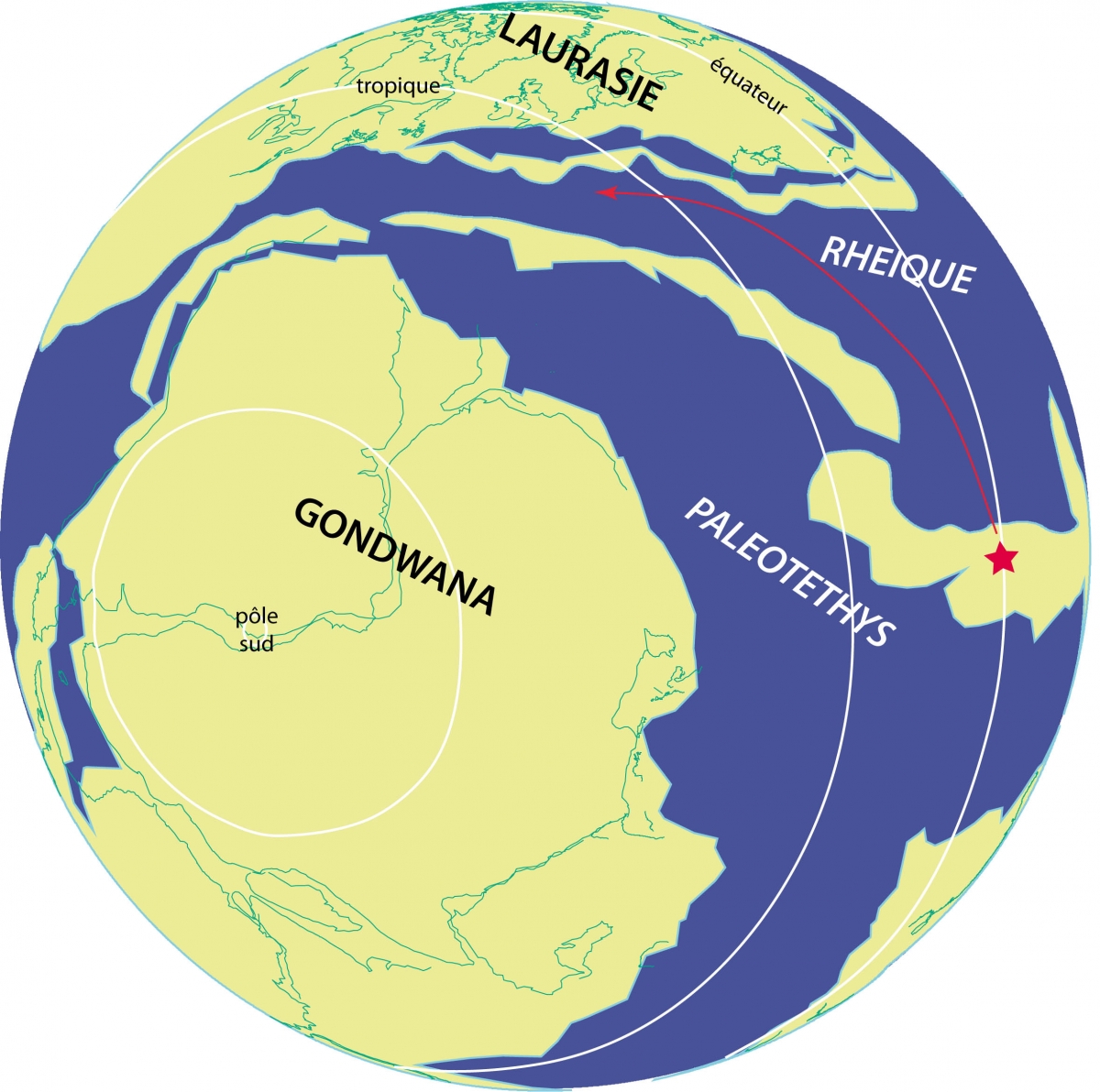
The Variscan terrains represent the ancient basement of the Mt Fort and Siviez-Mischabel Nappes. They originate from a volcanic mountain range (a cordillera) similar to the present day Andes, situated along the Gondwana border during part of the Palaeozoic (between 530 and 370 Ma). Following the mountain range's collapse during the Devonian (between 410 and 390 Ma) these Variscan terrains drifted away from Gondwana opening the Paleotethys Ocean behind them and closing the Rheic Ocean in front of them by subduction.
The star in the figure (modified from Stampfli et al. 2013) represents Palaeozoic rocks from the Valais during the Devonian. The arrow indicates the thousands of kilometres long voyage to the final destination. After this enormous displacement these drifting terrains finally collided with Europe during the Lower Carboniferous (between 350 and 330 Ma). This was followed by a second, more important collision between Gondwana and the enlarged Europe, then called Laurasia, South-western Europe and North-America, at the end of the Carboniferous (around 320 Ma).
This gigantic collision produced the large Variscan mountain belt extending from Mexico to Central Europe (dark green, reconstructions 315 to 290 Ma). It also produced Pangea.
In the Alps of Valais and all along the southern European border in Italy and Greece the collision with Gondwana was avoided. The Paleotethys Ocean continued its northward subduction under the Variscan terrains, creating a new volcanic mountain range (cordillera) during the Carboniferous and Permian. This explains the presence of granites of that age: Mt Rose granite 310 Ma, Fully granodiorite 307 Ma, Dent Blanche gneiss 290 Ma. Similar intrusive rocks can be found in the Southern Alps and to the east in Greece and Turkey.
In turn, this mountain range collapsed around 300 Ma producing numerous rifts like the Houillère Zone, the oldest rift in the Upper Carboniferous. This was followed with the Siviez-Mischabel Rift during the Permian. The Mt Colon Permian gabbros in the Dent Blanche Nappe (285 Ma) are associated with these rifts, which are situated behind the mountain range's volcanic arc.
This long lasting rifting period eventually thinned the mountain range's crust allowing the return of the sea initially during the Permian, in the Carnic Alps in Austria, and in Greece. When the rifting period finally ceased much later during the Lower Triassic, this marine transgression occurred in Switzerland covering the whole area with limestone and dolomite.
At certain times during the Triassic, the carbonate platform was reduced due to intense evaporation under a tropical climate permitting gypsum deposits (St Léonard) and salt deposits (Bex).
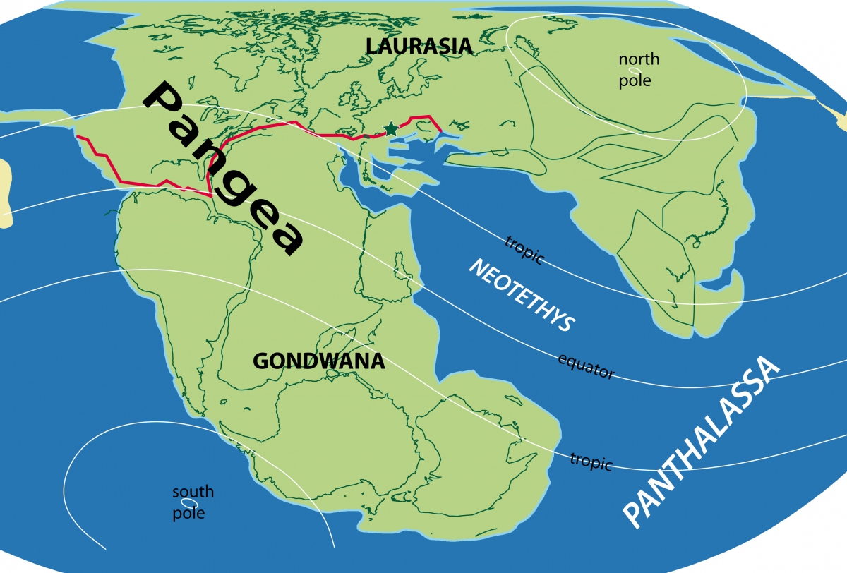
The opening of the Central Atlantic and Alpine Oceans during the lower Jurassic fractured the Pangea super-continent: Gondwana – Africa, India, Australia, Antarctica and South America, drifted away from Laurasia – North-America, Europe and Asia. In the diagram of the Lower Jurassic the Pangean fracture (red) produces the Alpine and Central Atlantic Oceans. The Valais (green star) is situated right on this gigantic fracture zone, several thousands of kilometres long.


 |
 |
 |
 |


+41 (0) 27 283 40 00
Place du Clos Lombard 6
1983 Evolène