


How old are our mountains?
The denser Alpine Ocean lithosphere detached and rocks previously buried at great depths were raised. These first mountains were strongly eroded and the large amounts of sediments were deposited in the molassic basin in the Swiss Plateau area. Folding and shortening of the Alps continued until the final folding of the Jura 5 Ma ago. Erosion continued to generate a slow mountain uplift by isostatic rebound, inducing earthquakes.
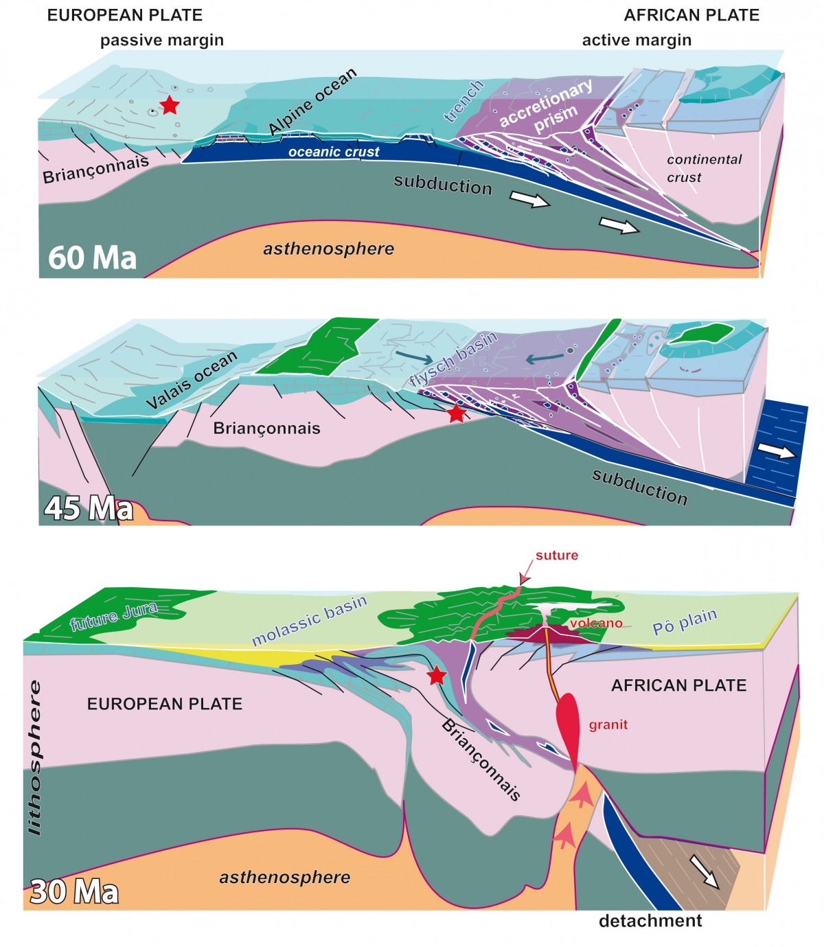
The formation of a mountain belt takes millions of years but when, exactly, did the first mountains appear? The Alpine region was mainly submerged under the Alpine Ocean 60 Ma with little relief. The beginning of the subduction of the Valais margin under the African plate changed the scenario radically.
The uplift of Africa, the upper plate, produced detritic sediments – sand or clay, called flysch – deposited on the subducting Valais margin. Fossils found in these flysch enable the exact positioning of the subduction trench, or the limit between two plates. 15 Ma were necessary, from 50 to -35 Ma, for the total subduction of the Briançonnais peninsula in Valais. The subduction trench then moved north of the Valais Ocean onto the future calcareous Wildhorn and Morcles Nappes 30 Ma ago. A radical change occurred when the trench was progressively replaced by a much shallower molassic basin extending to the future Jura area. At the same time in the Southern Alps, granites were emplaced at depth and volcanoes appeared at the surface.
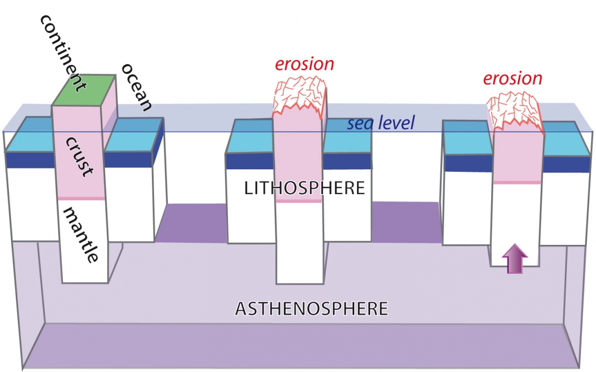
What happened? Following the burial of the Briançonnais crust under the African plate, the subduction processes are momentarily blocked. This continental crust and the denser oceanic crust that preceded it separate. This process called slab detachment triggered the uplift of a large portion of the upper African plate, creating the first mountains out of water.
NB: This situation is comparable with the present day Taiwan where the Chinese passive margin subducts under the Taiwanese volcanic arc, creating nearly 4000 metre high mountains. This allows the speculation that equally high mountains already appeared in the alpine area 20 to 30 Ma ago.
What happened after that?
The oceanic slab was detached from west to east up to the Carpathian Mountains, like a giant zipper a hundred kilometres deep opening over tens of Ma. Despite the blocked position of the European plate in the western Alps, the African plate continues to move slowly northward. Eventually between 25 and 5 Ma ago, a forced collision between the two continents occurs. As a consequence, huge slabs of European crust were thrust northwards over the molassic basin. The Mt-Blanc and French Aiguilles-Rouges massifs, and the Aar-Gotthard massifs in Central Switzerland are good examples of these very high mountain formations. The northward continental push eventually detached the entire molassic basin and triggered the folding of the Jura mountains.
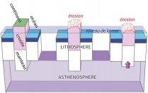
Following the Jura folding phase 5 Ma ago, movement ceased between the African and European plates. Erosion mainly due to the last 2 Ma of glacial activity has sculpted the Alpine relief. However isostatic readjustment responsible for the equilibrium of the lithosphere, ensures the compensation of erosion by the rising of the whole continent. Comparable to a melting iceberg whose 1/9th is always above the water surface, here, the asthenosphere plays the same role as water.
NB: The melting of the up to two kilometre thick Alpine ice cap also produced isostatic rebound with the raising of the lithosphere. However over many thousands of years, only by a few tens of metres.
The highest alpine reliefs certainly existed 10 to 5 Ma ago, and one can speculate that they were over 5000 metres high. Erosion and tectonic movements during the last 30 Ma enabled rocks buried 30-40 kilometres underground to reappear at the Earth's surface. This rising speed of 1 mm per year is still valid, however compensated by the same amount of erosion.
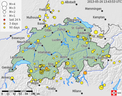
The relatively important seismicity in Valais is principally due to these isostatic readjustments, no longer linked to continental collision, but mainly to erosion. Earthquake magnitudes is usually between 1 and 3 on the Richter scale, occurring in the upper 10 km of the Earth's crust. Concentrated along old fractures they enable the release of accumulated tension. However, earthquakes of magnitude 5 or 6 are possible in Valais, several times a century.


 |
 |
 |
 |


+41 (0) 27 283 40 00
Place du Clos Lombard 6
1983 Evolène